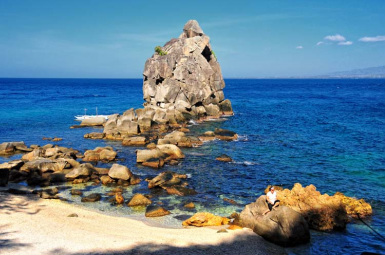
Dolphinwatch, Bais Bay, Bais City
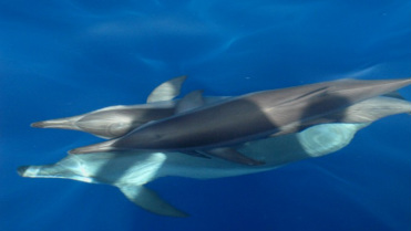
Described as one of the most successful dolphin-and-whale watching operations in the country, the cruise takes off from Port Capiñahan every 8:00 AM and traverses the Bay towards Tañon Strait, the narrow channel between Negros and Cebu islands, acknowledged to have one of the biggest concentrations of cetaceans in the world. Out of twenty-four cetaceans sighted in Philippine waters, eleven species are found in the Bais Bay – Tañon Strait area. Among these are dolphins and the pygmy sperm whale Kogia simos. The Bais City government operates two Dolphinboats. Five privately-owned pumpboats are also available. The cruise averages six hours. It may include side trips to Talabong Island and the White Sand Bar.
Talabong Island is located in South Bais Bay. It has an area of 217.59 hectares, heavily vegetated with 85% mangroves and 15% associated mangrove species, which provides an ideal habitat for significant fish and shellfish species, various marine life, birds and wildlife.
Bais City is 45 kilometers (approximately one hour travel time by all type vehicles) north of Dumaguete City.
White Sand Bar, Manjuyod
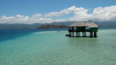
A 7-kilometer-long strip of white sand beach in the middle of North Bais Bay. Ideal for swimming and snorkeling. The area is submerged at high tide. Four cottages are available for guests. Manjuyod is 58.2 kilometers from Dumaguete City.
Travel to the White Sand Bar from Dumaguete is approximately 1:5 hours
Travel to the White Sand Bar from Dumaguete is approximately 1:5 hours
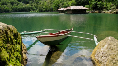
Balanan, Sandulot, Siaton
An expansive mountain resort developed around Balanan Lake, a humerus-shaped body of water, 25 hectares in surface area, 285 ms above sea level, oriented along a northwest-southeast direction (right). The lake encases a kilometer-long waterway ideal for water sports. Among the prominent features of the resort is a 4-kilometer circumferential pathway for trekking, a variety of pools for swimming, passenger bancas for boating, waterfalls for great photo-ops. Balanan has an old forest of almost a hundred balete trees, atop one of which is a treehouse. An 8-room hillside hotel, Balodge (left) provides air-conditioned comforts with a view of the lake. Other amenities include a thatched dining pavilion and a staffhouse. Balanan Lake Development Authority will implement regular rates beginning May 19. Entrance is free every Tuesday.
Balanan is 60 kilometers from Dumaguete City, or approximately 1:5 hours travel time.
The Twin Lakes, Balinsasayao and Danao, Sibulan
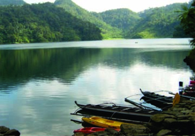
The Twin Lakes Natural Park is approximately 8,000 hectares, part of the 133,000-hectare Geothermal Reserve managed by the PNOC. The main features are Lakes Balinsasayao and Danao, contained in adjacent calderas 1,000 meters above sea level and separated by a ridge 20 meters in width. The lakes are completely surrounded by forest and lush vegetation of about 3,462 hectares spread over the Guintabon, Kabalin-an and Guinsayawan mountain ranges which serve as protection dikes to the lakes. The bigger lake Balinsasayao has a surface area of 76.25 hectares, Danao 30 hectares. Depth is approximately 80 meters, with Danao’s water level 10.04 inches higher. Volume of water in both lakes is estimated at 77,600 cubic meters, with no visible outlet. Seepage feeds the geothermal reserves tapped by PNOC. About a kilometer below the access slope to the Twin Lakes is Kabalin-an Pond, a shallow body of fresh water about 2.4 hectares, beside which the Provincial Government has built a visitor’s reception center and parking lot. The banks of Kabalin-an provide refreshing picnic spaces. Discovery of the area is attributed to Don Miguel Patero in 1885. The American missionaries Mr. Bell and Dr. Carson, who had evacuated to the Twin Lakes, called a meeting in the area to unite the guerilla forces during WWII. The
The Twin Lakes are approximately 1 hour by 4-wheel drive or motorbike from Dumaguete City.
Apo Island, Dauin
A 72-hectare, 200-meter high volcanic island about 5 kilometers off the municipality of Dauin. Five pocket beaches of white pebbles, two mangrove lagoons, and a lighthouse. The Apo Island Protected Landscape and Seascape comprises 691.45 hectares (72 terrestrial, the remaining is the marine area surrounding the island). An average total coral cover of 63.1% and a magnificent variety of corals and marine life led to Apo Island’s being acclaimed as one of the world’s Ten Best Divesites. Coconut Point is referred to as the best divesite in southern Visayas. In “Clown-fish City” the colorful Amphiprion melanopus inhabit anemones that have colonized seven large coral heads. This underwater splendor is replicated in the Schedd Aquarium of Chicago. Apo Island is approximately 45 minutes by motorized outrigger (pumpboat) from Dauin.
Casaroro Falls, Apolong, Valencia
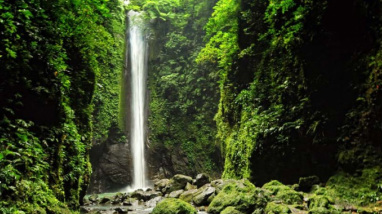
Valencia’s elevation at 715 feet above sea level endows it with a cool climate. Trekkers access Casaroro Falls (right) via three hundred concrete steps which descend into a scenic site surrounded by steep rock walls where a single column of sparkling water plunges almost a hundred feet into a chilly swimming caldera. The Municipal Government has erected picnic sheds for the visitors who frequent the area.
Casaroro is approximately 30 minutes by 4-wheel drive or motorbike from Dumaguete City.
Mabinay Caves, Mabinay
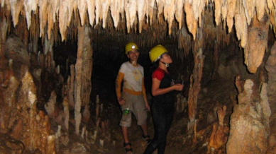
The prevalence of limestone rock and extensive karst phenomena secures Mabinay’s claim to being the Cave Town of Negros Oriental. According to the locals, there are over 400 caves honeycombing Mabinay’s lower regions. In 1989-1990, the Belgian-Dutch-Philippine Club undertook an expedition and identified 45. Among these:
Bulwang – 159 meters long, with icicle-like dripstone. The Provincial Government has installed a walkway into the cave, and amenities at the approach such as a visitors’ reception building and dining hall.
Odloman – at 8,870 meters, went on record as the second longest cave system in the Philippines. Accessed by rappelling through a hole in the ceiling or by swimming 20 meters across an underground river, Odloman has large galleries, many narrow corridors, active streams and more than enough difficult obstacles to lure extreme cavers.
Cayaso – with a subterranean river flowing through its main chamber, measures 2,222 meters long to rank 9th longest cave in the country. Other caves of note:
Baliw – 769 meters long, with white concretions called “white forest.”
Mambajo – 670 meters long (right), has a chimney access and a subterranean river flowing towards a siphon to emerge in Mambajo 2.
Kabugan – 373 meters, with a large opening called the “sunny walk” midway towards a bat-colonized area. (On the other side of the valley is Tokko, a shallow cave only 20 meters deep, believed to be part of the Kabugan system.)
Panligawan and Pandalihan – popular among amateur cavers, comparatively shallow at 143 and 282 meters, respectively. The dome-shaped Panligawan has a skylight, and wide and flat ground ideal for in-cave camping.
Mabinay is an interior highland town 87 kilometers northwest of Dumaguete City, through which a “short cut” highway exits to neighboring Negros Occidental. It is predominantly agricultural, with sugar as the main product. A side-trip to take is Mabinay Spring which feeds a lake set amid lush vegetation in the heart of the poblacion, ideal for picnics and swimming.
Poblacion Mabinay is about an hour and a half north of Dumaguete City by all types of vehicles.
Mt. Kanlaon, Canlaon City
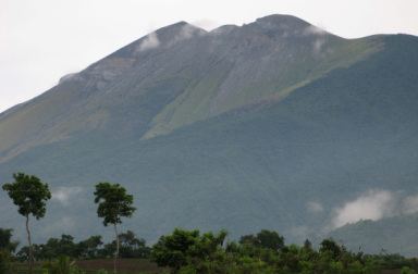
Mt Kanlaon, the tallest peak in Central Visayas and among the highest in the country, rises 8,050 feet above sea level on the boundary between the two Negros provinces. The crater is approximately 9.5 kilometers from the Canlaon City center. Mt. Kanlaon National Park covers 24,577 hectares, 3,296 hectares or 8% of which are under Negros Oriental jurisdiction. The volcano endows Canlaon City, nestled on its northeastern slopes, with cool weather, fertile soil, and an abundance of natural attractions. The city sprawls at an elevation of 2,600 feet above sea level. It is the take-off point for mountain climbing to the volcano summit, Makawiwili Ridge, and Margaha Valley; or for excursions into a number of waterfalls including Sandugan, Mananawin, Inihawan, Kipot and Sudlon. There are as well unusual sites such as the Masulog Rice Terraces, Bucalan Hot Springs, the OISCA Model Farm, Camp Mapot, and the natural water slides of Padudusan Falls.
Inihawan , also called the “Enchanted Falls,” plunges 100 feet into a verdant setting, approximately 8 kms northeast of the city proper.
Kipot is a bottle-shaped waterfall cascading over rocks to form a wide and deep pond ideal for boating and swimming, about 5 kms from city proper.
Camp Mapot is set on a plateau 5,000 above sea level, on the eastern flank of Mt Kanlaon. Pine trees and hillside springs abound in the area which often serves as jump-off point for mountain climbers essaying the volcano.
